Strengthen your decisions with unmatched accuracy
Tianmu's cutting-edge soil moisture technology delivers daily insights into soil moisture levels across any location globally, bringing revolutionary changes to agriculture, business, and environmental protection.
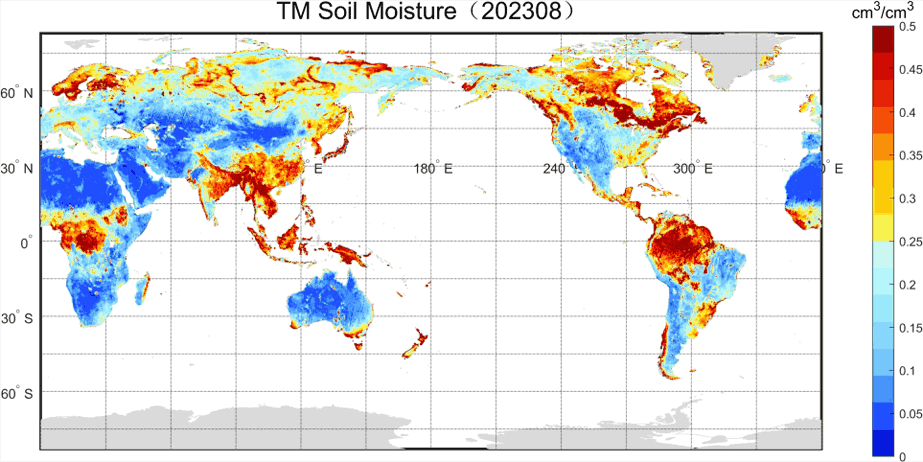 Soil Moisture (2023.8 East of China)
Application
Data Sheets
| L2 | Soil Moisture |
|---|---|
| Contents | The product primarily contains information on measurement time, location, soil moisture, soil moisture quality, and the raw data used in soil moisture retrieval. |
| File Naming | LEOX_GNOSR_YYYYMMDD_hhmmss_UUUUU_L2_VSM.HDF |
| File Format | HDF |
| Technical Specifications | Spatial Resolution: 1×6KM |
| Daily data growth from a single satellite | About 55MB |
| Image | |
| L1 | GNSS L1 reflection data |
|---|---|
| Contents | The primary content of the product includes: time and location of GNSS reflection events, ID of the reflected GNSS satellite, position and velocity of both the reflected GNSS satellite and the TM satellite, normalized radar cross section at the specular reflection point, and LES (Likely Error Statistics). |
| File Naming | LEOX_GNOSR_YYYYMMDD_hhmmss_UUUUU_L1_C1.HDF ... LEOX_GNOSR_YYYYMMDD_hhmmss_UUUUU_L1_C8.HDF Channels 1-2 are used for GPS signal reception, channels 3-5 for BDS, channels 6-7 for GALILEO, and channel 8 for GLONASS. |
| File Format | HDF |
| Daily data growth from a single satellite | About 4GB |
| L0 | Raw payload data packet |
|---|---|
| Contents | Raw observation data of the payload, including low-speed and high-speed packet data. |
| File Naming | LEOX_GNOSR_L0_YYYYMMDD_hhmmss_UUUUU_LOW.DAT(Duration: 1h) LEOX_GNOSR_L0_YYYYMMDD_hhmmss_UUUUU_HIG.DAT(Duration: 1h) |
| File Format | BIN |
| Daily data growth from a single satellite | About 2GB |