牧星巡宇,立业兴邦
Aerospace Tianmu(chongqing)Satellite Technology Co.,Ltd, established in January 2023, is the core entity for low-Earth orbit satellite data application services under CASIC.
Tianmu is committed to building an extensive, low-cost satellite network with broad coverage, promoting the establishment and application of space infrastructure and strategic deployment. The company aims to secure a leading position in space-based information applications, with the goal of becoming a world class provider of space information application services.
Building a new meteorological analysis system based on future-oriented space infrastructure


The Tianmu constellation is establishing an occultation-based meteorological observation system composed of both sun-synchronous and low-inclination orbits. This system provides 24/7 global observation capabilities with dense coverage in mid-to-low latitudes. It comprehensively gathers environmental data from the Earth's surface to near space, utilizing predictive models to distill and integrate complex data into highly usable products.
Land surface data
Study land surface using GNSS scatterometry and precise altimetry (GNSS-R), to measure soil moisture.
Sea surface data
Study sea surface using GNSS scatterometry and precise altimetry (GNSS-R), to measure ocean wind speed and sea ice.
Atmospheric data
Monitor our atmosphere with precise GNSS radio occultation (GNSS-RO) soundings to improve global weather forecasting accuracy.
Ionospheric data
Monitor the ionosphere using measurements of electron density and scintillation to augment GNSS accuracy, providing new insights into weather changes.
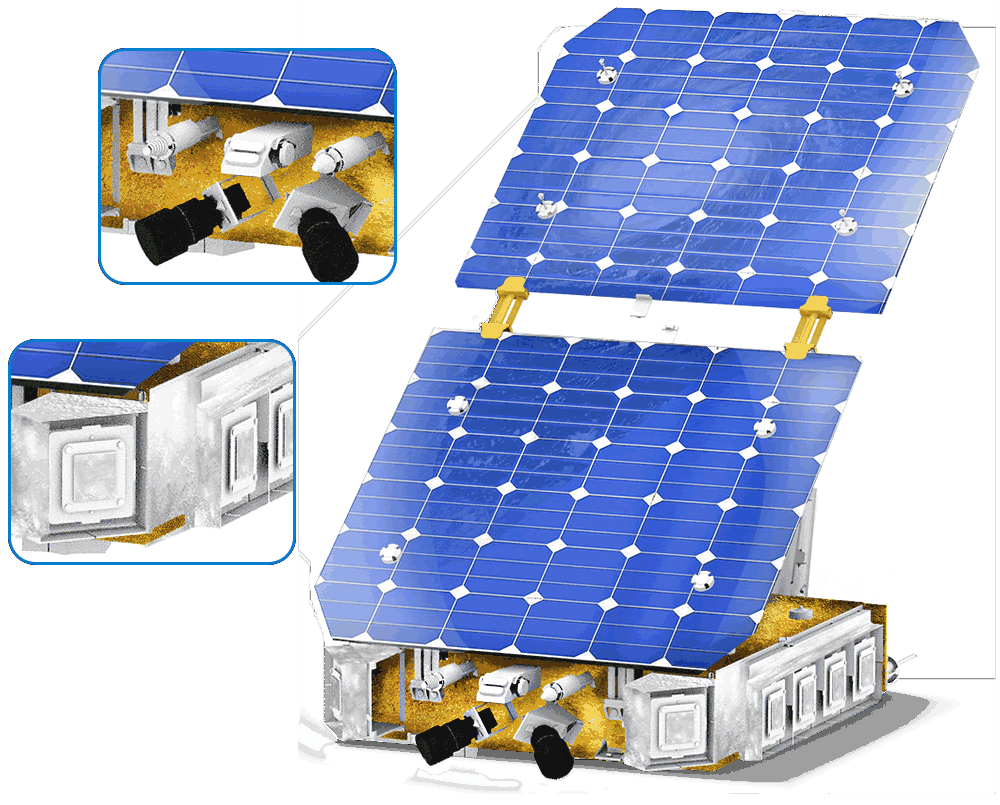
Tianmu SpecificationsEquipped with GNSS occultation and ocean reflection detection payloads, it supports the BeiDou, GPS, Galileo, and Glonass navigation systems, providing powerful capabilities for acquiring global meteorological information.


Launch Mass
55kg
Satellite Design Life
≥5 Years
End-of-Life Reliability
≥0.6
Orbital Altitude
520km
Tianmu by numbers
23
Number of satellites in orbit
30000+
Current daily atmospheric profile count
90000+
Daily atmospheric profile count upon constellation completion
3 hours
Global ocean surface can be covered in
6 hours
All grid points can be covered in
Tianmu launch history


Kuaizhou-1A
Jiuquan Satellite Launch Center
Tianmu 15-18

Kuaizhou-1A
Jiuquan Satellite Launch Center
Tianmu 19-22

Kuaizhou-1A
Jiuquan Satellite Launch Center
Tianmu 11-14

Kuaizhou-1A
Jiuquan Satellite Launch Center
Tianmu 07-10

Kuaizhou-1A
Jiuquan Satellite Launch Center
Tianmu 03-06

Ceres-1
Jiuquan Satellite Launch Center
Tianmu 01、Tianmu 02

Long March 2D
Taiyuan Satellite Launch Center
Tianmu 00
Products and services

Typhoon Predict
Powered by our Machine Learning and Artificial Intelligence technologies, Tianmu is able to track Typhoon in Real-Time and accurately predict Typhoon Paths backed by a comprehensive global data archive.

Smart Earth
Real-time tracking of global climate provides comprehensive data support for precise decision-making.

Data Products
High-resolution, high-accuracy data products are based on 24/7 continuous observation and information gathering across global land, ocean, atmosphere, and ionosphere layers.

Weather API
Tianmu is committed to creating easy-to-use, flexible, and developer-friendly APIs, and supporting your company in getting the most out of them.
Applications
Disaster Prevention and Mitigation
Integrating multi-source data from meteorology, land resources, and hydrology, we are building a monitoring platform with multi-hazard types, and multi-department coordination to enhance disaster prevention and mitigation effectiveness.
Ocean Navigation
Intelligent data helps optimize voyage, avoid adverse weather, and guide emergency decisions during navigation. This reduces energy consumption and enhances the safety of ocean voyages.
New Energy
Accurate weather forecasting data can assist in optimizing power plant siting decisions, increasing power plant ROI and investment returns. This data also helps reduce maintenance costs, improve power system dispatch efficiency, and decrease fluctuations in grid power supply.
Smart Agriculture
Integrating meteorological data throughout the entire agricultural production process, including disaster climate event forecasting and warning, crop growth monitoring, yield estimation, and disaster damage assessment, making agricultural smarter.
Port Management
Deeply integrating data with oceanographic, hydrological, vessel, port scheduling, and maritime control information, we are developing port meteorological warning capabilities. This ensures the safety and efficiency of port operations and enhances overall port management.
Tourism
By integrating meteorological data with information such as tourist attraction heatmaps, we provide travelers with trip recommendations. This supports the implementation of weather index insurance for tourism, minimizing the impact of severe weather on travel plans and enhancing the overall visitor experience.
Customers who trust us