Application
Data Sheets
| L2 | Ocean Wind Speed |
|---|---|
| Contents | The product provides measurement time, location, retrieved wind speed, a quality flag indicating the reliability of the wind speed, and the original measurements used in the retrieval process. |
| File Naming | LEOX_GNOSR_YYYYMMDD_hhmmss_UUUUU_L2_SWS_COMB.HDF |
| File Format | HDF |
| Technical Specifications | Spatial Resolution: 25KM Accuracy of Ocean Wind Speed: <2 m/s (for wind speeds less than 20 m/s) |
| Daily data growth from a single satellite | About 55MB |
| Image | 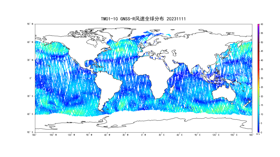 |
| Quality Assessment Results | Sea surface wind speed distribution Indicator Requirements: The wind speed distribution ranges from 0 to 25 m/s. Test Method: Analysis of the distribution of reflected L2 wind speeds derived from three days of business data. Test conditions: 1) Data source: April 10th to 13th, 2023. 2) Test Results: 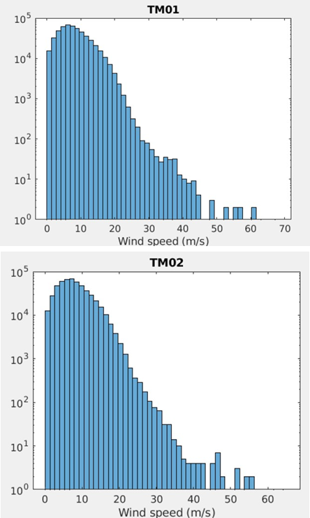 3) Test Conclusion: The ocean wind speed distribution of Tianmu 01/02 satellites meets the test requirements. Accuracy assessment of ocean wind speed products Indicator Requirements: Root mean square error (RMSE)<2 m/s. Test Method: Compare the operational ocean wind speed product with the ECMWF reanalysis field wind speed and quantify the difference using root mean square error. Test conditions: 1) Data source: February 2nd to 18th, 2023. 2) Test Results: TM01: 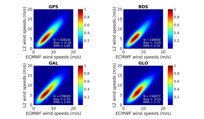 TM02: 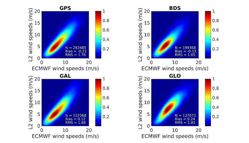 3) Test Conclusion: The ocean wind speed product for Tianmu01-02 satellites have demonstrated excellent accuracy, with an RMSE of less than 2 m/s, fulfilling the performance requirements. |
| L1 | GNSS L1 reflection data |
|---|---|
| Contents | The primary content of the product includes: time and location of GNSS reflection events, ID of the reflected GNSS satellite, position and velocity of both the reflected GNSS satellite and the TM satellite, normalized radar cross section at the specular reflection point, and LES (Likely Error Statistics). |
| File Naming | LEOX_GNOSR_YYYYMMDD_hhmmss_UUUUU_L1_C1.HDF ... LEOX_GNOSR_YYYYMMDD_hhmmss_UUUUU_L1_C8.HDF Channels 1-2 are used for GPS signal reception, channels 3-5 for BDS, channels 6-7 for GALILEO, and channel 8 for GLONASS. |
| File Format | HDF |
| Daily data growth from a single satellite | About 4GB |
| L0 | Raw payload data packet |
|---|---|
| Contents | Raw observation data of the payload, including low-speed and high-speed packet data. |
| File Naming | LEOX_GNOSR_L0_YYYYMMDD_hhmmss_UUUUU_LOW.DAT(Duration: 1h) LEOX_GNOSR_L0_YYYYMMDD_hhmmss_UUUUU_HIG.DAT(Duration: 1h) |
| File Format | BIN |
| Daily data growth from a single satellite | About 2GB |