High-quality data empowered by cutting-edge satellite technology
The Tianmu-1 constellation provides space-based monitoring of the ionosphere, allowing us to retrieve electron density data. This capability is instrumental in advancing space weather research and forecasting, thereby enhancing the reliability of radio communications, satellite operations, and navigation systems.
Application
Data Sheets
| L2 | Electron Density |
|---|---|
| Contents | Each electron density profile product contains a profile of electron density and associated metadata for a single occultation event. The metadata includes the occulting satellite (GPS/BDS/GALILEO/GLONASS), timestamp, tangent point, and electron density values. |
| File Naming | ionPrf_GNOS.LLL.YYYY_DDD_HH_MM_GGG.nc |
| File Format | NETCDF |
| Technical Specifications | Vertical Resolution: <1KM Peak electron density error: <20% |
| Daily data growth from a single satellite | About 5MB |
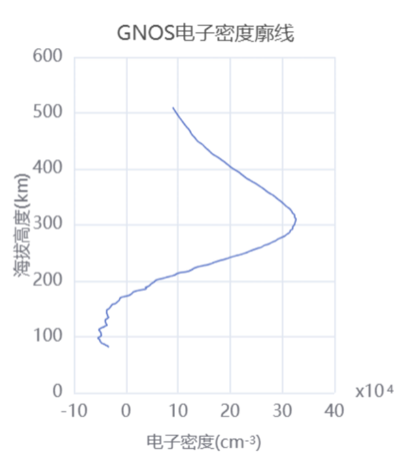
| image | 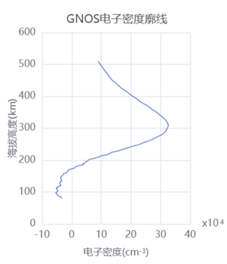 |
| Quality Assessment Results | Altitude interval for ionospheric occultation measurements Indicator Requirements: Altitude range from 80 to 510 kilometers. Test Method: Statistical analysis of the altitude range of ionospheric occultation L2 events generated by the operational system over 3 days. Test conditions: 1) Data source: January 13th to 15th, 2023. 2) Test Results: TM01: 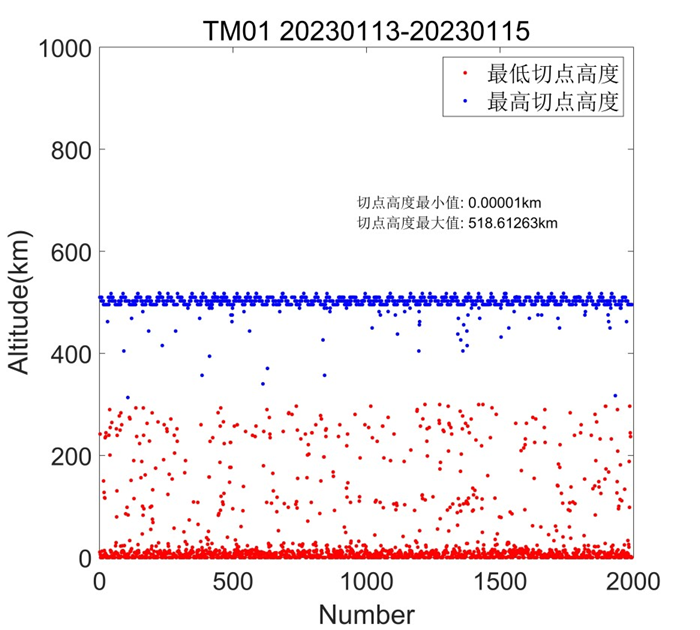 TM02: 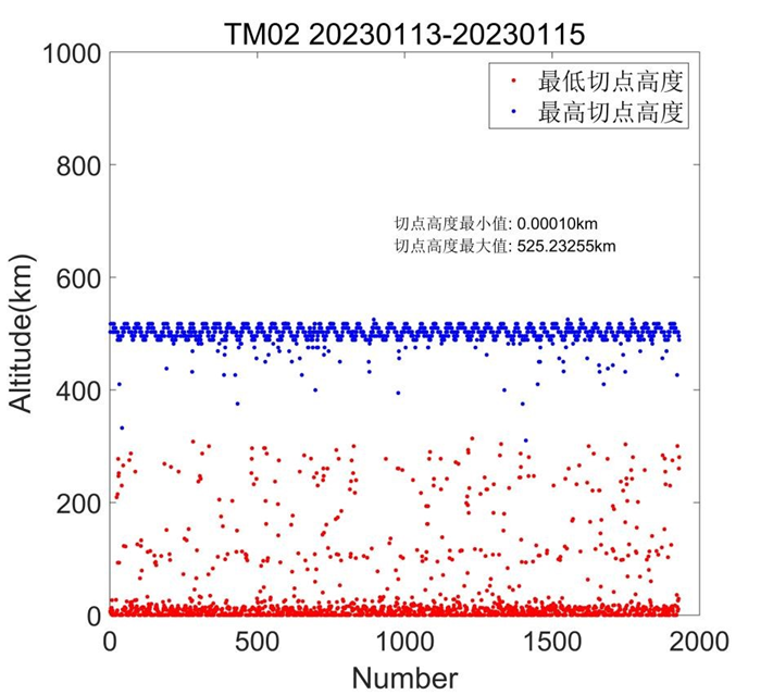 3) Test Conclusion: The altitude range of ionospheric occultation detection for Tianmu 01/02 satellites meets the test requirements. Accuracy assessment of ionospheric occultation products Indicator Requirements: The NmF2 (peak electron density of the F2 layer) derived from ionospheric occultation is considered compliant if its standard deviation relative to the NmF2 measured by vertical incidence sounding is less than 20%. Test Method: To evaluate the accuracy of L2 ionospheric products, NmF2 from near-real-time L2 ionospheric electron density profiles is compared with NmF2 from ionosondes. Data from at least two months are used, with temporal and spatial matching criteria of a time difference within 30 minutes and a spherical distance between the occultation sub-satellite point and ionosonde less than 200 km. The standard deviation of NmF2 is calculated to quantify the agreement between the two datasets. Test conditions: 1) Data source: UML global ionosonde data and Tianmu01 and Tianmu02 ionospheric occultation L2 products for the time frame of January 9 to March 31, 2023. 2) Test Results: The figure below presents the linear correlation and statistical discrepancy between NmF2 derived from Tianmu01, Tiammu02, and ionosondes. 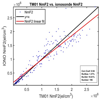 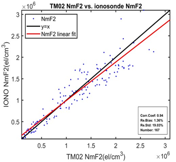 3) Test Conclusion: The NmF2 values from Tianmu01 and Tianmu02 L2 products generated near-real-time during January 9, 2023 to March 31, 2023 were temporally and spatially matched with those from ionosondes. After removing 10% of outliers, the standard deviation of NmF2 was calculated for 196 matched data pairs for Tianmu01 and 167 pairs for Tianmu02. The results showed that the standard deviation of NmF2 was 19.61% for Tianmu01 and 19.03% for Tianmu02, indicating that both Tianmu01 and Tianmu02 L2 ionospheric products met the accuracy requirements. |
| L1b | Ionospheric Total Electron Content | Ionospheric Excess Phase data file |
|---|---|---|
| Contents | The TEC product offers a comprehensive dataset for individual occultation events, encompassing occultation TEC, scintillation indices, and ancillary data. The product content includes the PRN of the occulting GPS/BDS/GALILEO/GLONASS satellite, time, tangent point location, absolute TEC values, and scintillation measurements. | GNOS L1 data provides the ionospheric excess phase and auxiliary data for individual occultation events. The data includes time, PRN number of the occulting GNSS satellite, position and velocity of the occulting GNSS satellite, position and velocity of the LEO satellite, signal-to-noise ratio (SNR), and occultation flag. |
| File Naming | podTec_GNOS.LLL.YYYY_DDD_HH_MM_GGG.nc | ionPhs_GNOS.LLL.YYYY_DDD_HH_MM_GGG.nc |
| File Format | NETCDF | NETCDF |
| Daily data growth from a single satellite | About 1.8GB | About 200MB |
| L1a | Ionospheric occultation channel observation data |
|---|---|
| Contents | The occultation data packages comprise GNSS occultation carrier phase and pseudorange measurements, segmented into atmospheric and ionospheric occultation categories. |
| File Naming | occIon_GNOS.LLL.GGG.YYYY.DDD.SSSSS.UUUUU.AD.ROX |
| File Format | ROEX(GNSS Radio Occultation Data Independent Exchange Format) |
| Daily data growth from a single satellite | About 500MB |
| L0 | Raw payload data packet |
|---|---|
| Contents | Raw occultation payload observation data, including positioning and occultation data. |
| File Naming | LEOX_GNOSO_L0_YYYYMMDD_hhmmss_UUUUU.DAT |
| File Format | BIN |
| Daily data growth from a single satellite | About 3GB |