Application


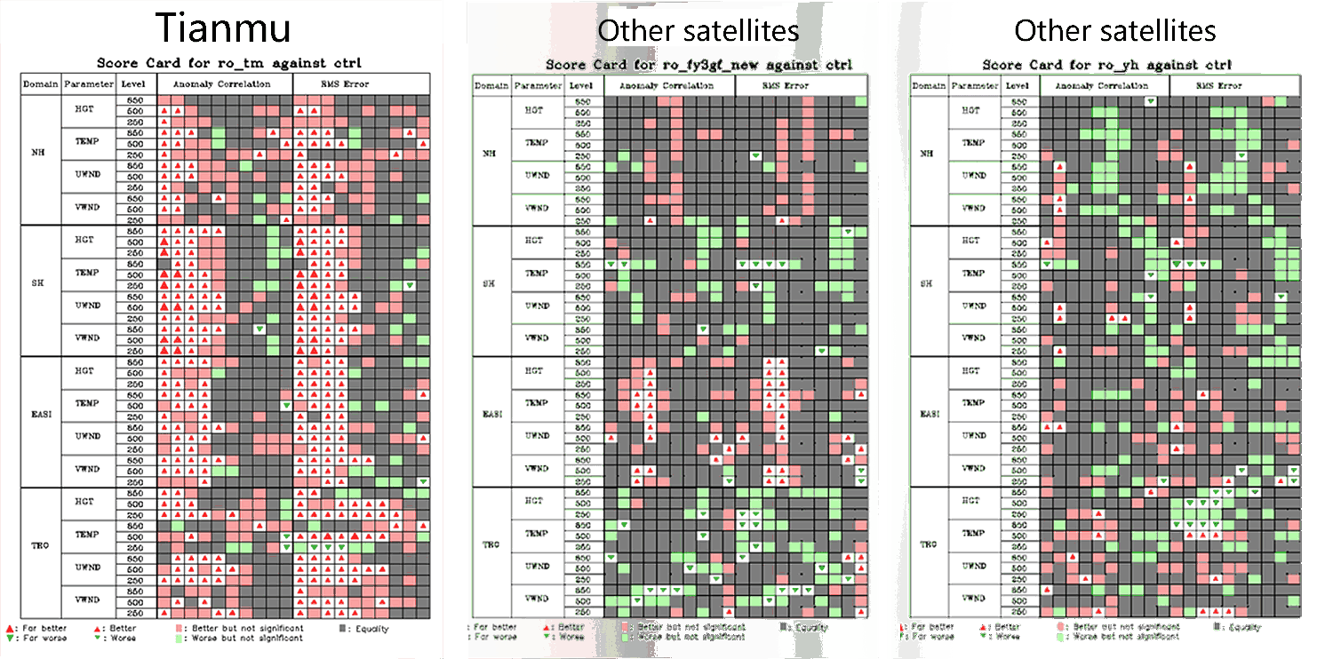
Forecast performance metric card
Legend: Red: Assimilated occultation data improved the forecast. Green: Assimilated occultation data worsened the forecast. Triangle size represents the magnitude of the effect.
Based on the forecast scorecard from the Numerical Prediction Center of the China Meteorological Administration, the assimilation of Tianmu occultation data into the CMA-GFS4.0 system has shown significant positive impacts on forecasts in all regions (Northern Hemisphere, Southern Hemisphere, East Asia, and the tropics), outperforming other occultation data sources.
bias
std
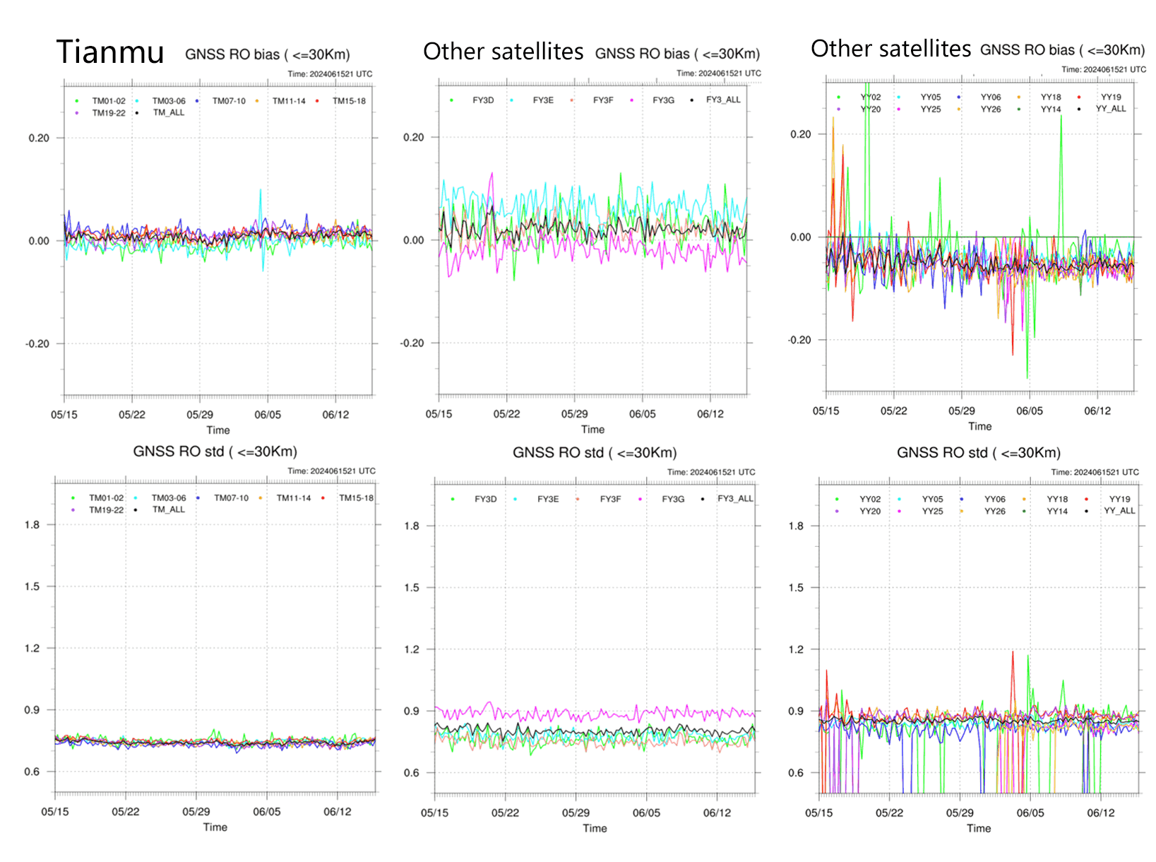
The China Meteorological Administration's assessment indicates that Tianmu occultation data offer higher accuracy, with smaller mean deviation and standard deviation compared to other occultation data.
Accuracy assessment of occultation data
Data Sheets
| L2 | Dry Atmosphere | Moist Atmosphere |
|---|---|---|
| Contents | The dry atmospheric profile product provides atmospheric profiles and auxiliary data from a single occultation event. The product content includes time, satellite number of occultation GPS/BDS/GALILEO/GLONASS, tangent point location, bending angle, refractive index, atmospheric density, dry temperature, and dry pressure. | The moist atmospheric profile product provides atmospheric profiles of moisture and auxiliary data from a single occultation event. The product content includes time, satellite number of occultation GPS/BDS/GALILEO/GLONASS, tangent point location, temperature, pressure, and specific humidity. |
| File Naming | atmPrf_GNOS.LLL.YYYYMMDD_HHMM_GGG.nc atmBufr_GNOS.LLL.YYYYMMDD_HHMM_GGG.bufr | wetPrf_GNOS.LLL.YYYYMMDD_HHMM_GGG.nc |
| File Format | NETCDF BUFR | NETCDF |
| Technical Specifications | Vertical Resolution: <1KM Average Refractive Index Deviation: ≤1%(Near the surface~5km) ≤0.5%(5~30km) Average Temperature Deviation: ≤1K(Near the surface~5km) ≤0.5K(5km~30km) | - |
| 单星日增量 | atmPrf: about 250MB atmBufr: about 22MB | About 5MB |
| image | 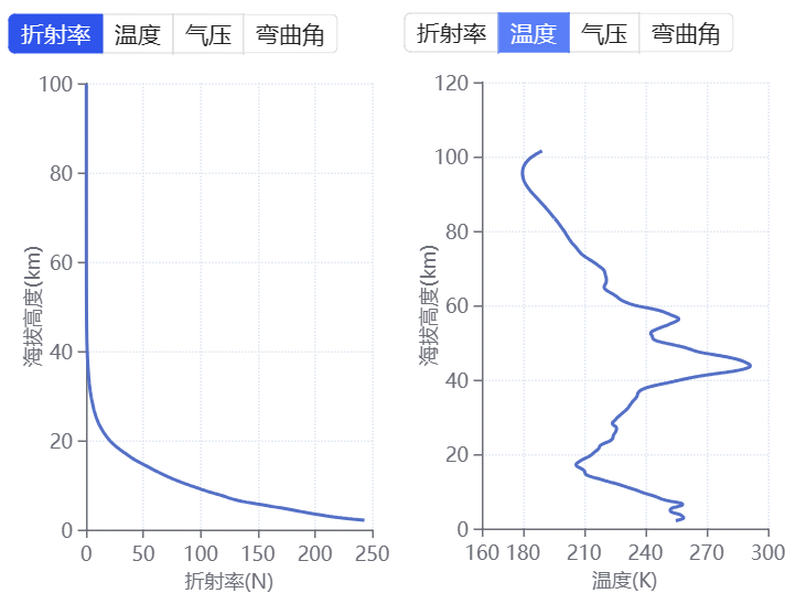 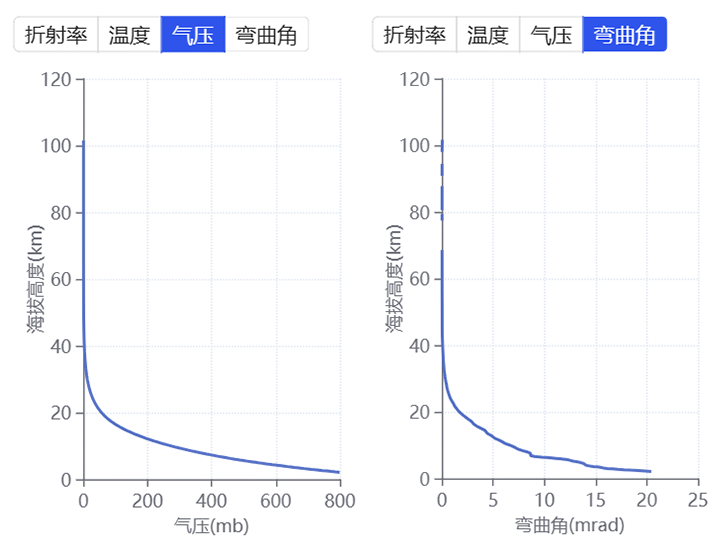 | 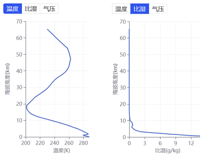 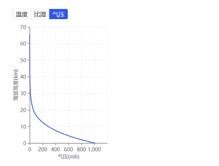 |
| Quality Assessment Results | Assessment of the Altitude Range for Atmospheric Occultation Detection Indicator Requirements: Altitude range from 0.2 to 60 kilometers. Test Method: Statistically analyze the altitude range of L2 occultation events generated by the business system over 3 days. Test conditions: 1) Data source: January 13th to 15th, 2023. 2) Test Results: 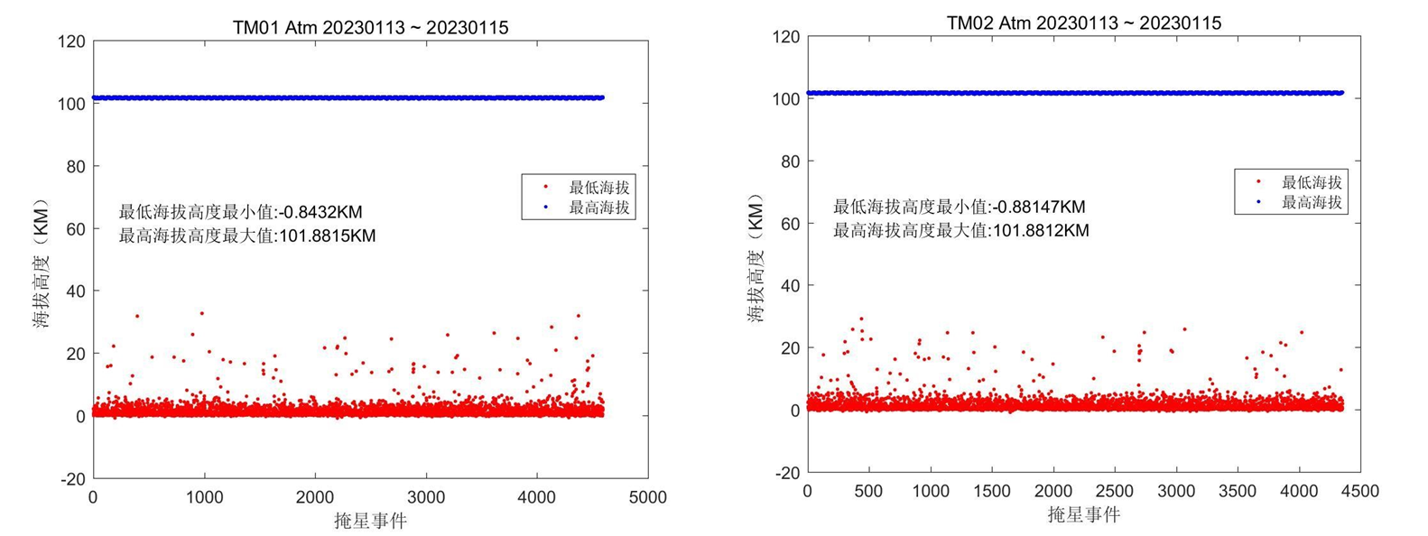 3) Test Conclusion: The altitude range of atmospheric occultation detection for Tianmu 01/02 satellites meets the test requirements. Accuracy assessment of Atmospheric Occultation Refractive Index Indicator Requirements: A mean deviation of less than 1% (between 5km and 35km) is considered acceptable Test Method: A statistical analysis will be conducted to evaluate the accuracy of atmospheric occultation refractivity by comparing near real-time L2 dry atmospheric profiles generated operationally with analysis or reanalysis model data over a three-day period. Test conditions: 1) Data source: April 2nd to 4th, 2023. 2) Test Results: 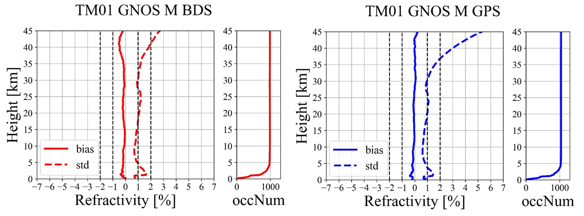 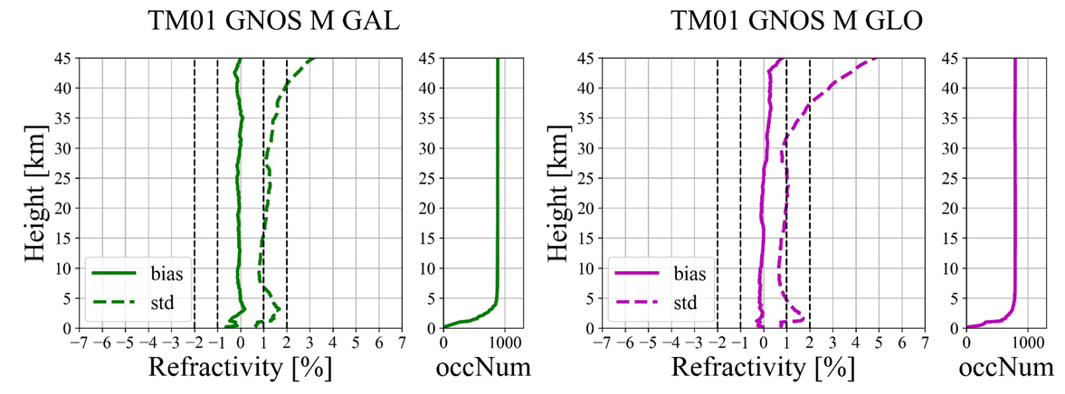 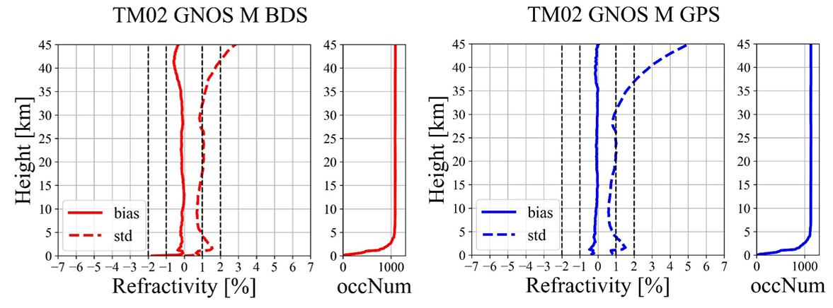 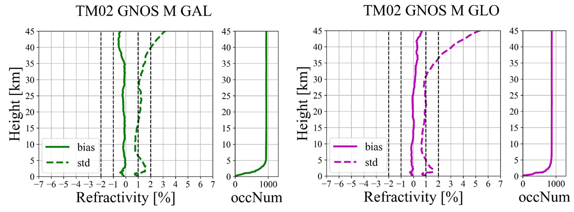 3) Test Conclusion: Testing has confirmed that the atmospheric occultation refractivity obtained from Tianmu 01/02 satellites meets the required accuracy. | Accuracy assessment of Atmospheric Occultation Temperature Indicator Requirements: A mean deviation of less than 1K (between 5km and 35km) is considered acceptable. Test Method: A statistical analysis will be conducted to evaluate the accuracy of atmospheric occultation temperature by comparing near real-time L2 moist atmospheric profiles generated operationally with analysis or reanalysis model data over a three-day period. Test conditions: 1) Data source: April 2nd to 4th, 2023. 2) Test Results: TM01: 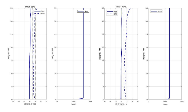 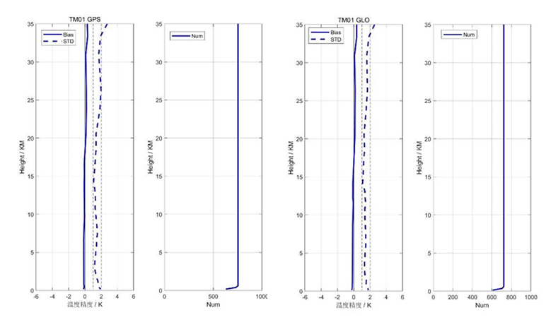 TM02: 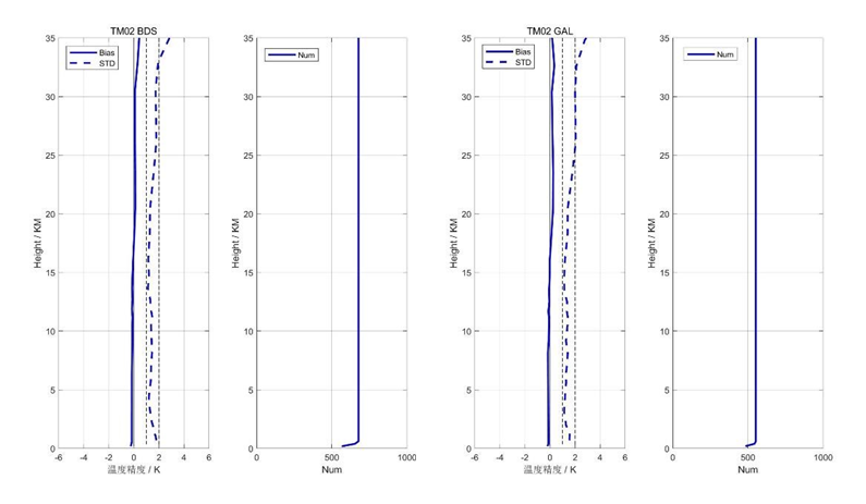 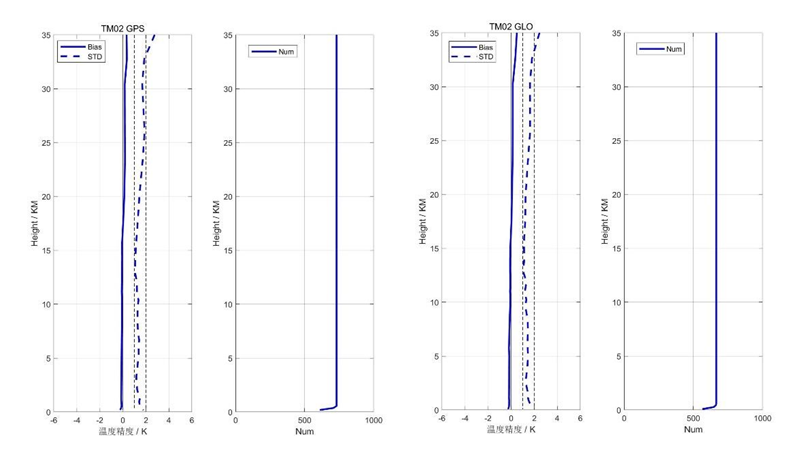 3) Test Conclusion: Testing has confirmed that the atmospheric occultation temperature accuracy of Tianmmu 01/02 satellites meets the test requirements. |
| L1b | Precise orbit and clock data for LEO satellites | Atmospheric Excess Phase data file |
|---|---|---|
| Contents | Precise orbit product data for LEO satellites Precise clock product data for LEO satellites | The Global Navigation Satellite System Occultation (GNOS) Level 1 atmospheric excess phase data provides detailed measurements for each occultation event, including time, GNSS satellite and LEO satellite positions and velocities, signal-to-noise ratio, and occultation flag. |
| File Naming | leoSp3_LLL_YYYY.DDD.SSSSS.UUUUU_sys.sp3 leoClk_LLL_YYYY.DDD.SSSSS.UUUUU_sys.clk | atmPhs_GNOS.LLL.YYYY_DDD_HH_MM_GGG.nc |
| File Format | sp3 clk | NETCDF |
| Daily data growth from a single satellite | sp3: about 1.5MB clk: about 1.5MB | about 1.7GB |
| L1a | GNSS satellite positioning observation data | LEO satellite positioning observation data | Atmospheric occultation data |
|---|---|---|---|
| Contents | Positioning observation data, including carrier phase and pseudorange measurements from GNSS satellites received by the positioning channel. | Including LEO satellite orientation data and real-time location data. | Occultation packet data consists of GNSS occultation carrier phase and pseudorange observations. Occultation packets are divided into atmospheric and ionospheric occultation. |
| File Naming | podObs_LLL_AD_YYYY.DDD.SSSSS.UUUUU_SYS.rnx2 | leoAtt_LLL_YYYY.DDD.SSSSS.UUUUU_txt leoPos_LLL_YYYY.DDD.SSSSS.UUUUU_txt | occAtm_GNOS.LLL.GGG.RR.YYYY.DDD.SSSSS.UUUUU.AD.ROX |
| File Format | RINEX(Receiver Independent Exchange Format V2.10) | txt | ROEX(GNSS Radio Occultation Data Independent Exchange Format) |
| Daily data growth from a single satellite | About 500MB | leoAtt:about 6MB leoPos:about 13MB | About 1GB |
| L0 | Raw payload data packet |
|---|---|
| Contents | Raw occultation payload observation data, including positioning and occultation data. |
| File Naming | LEOX_GNOSO_L0_YYYYMMDD_hhmmss_UUUUU.DAT |
| File Format | BIN |
| Daily data growth from a single satellite | About 3GB |